WISkies
New member
- Joined
- Oct 29, 2024
- Messages
- 13
- Points
- 3
As far as I know, this term was coined by Skip Talbot, a chaser I've long held in high regard, to describe the appearance of a supercell updraft base when it gets occluded by the RFD clear slot punching through it.
However, I've since noticed that NOAA also uses it in their field guide. I don't know if their usage of the term pre-dates Skip's or if they got it from him.
Either way, it's certainly an apt description of the appearance and can help you get your bearings on the storm structure. I've taken a few of my own images and outlined where the "horseshoe" is or may be.
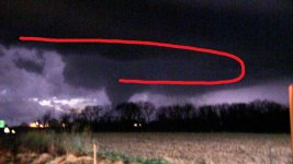
March 15, 2016; Hanna City, IL. Looking west-northwest, despite darkness having set in with just a bit of twilight remaining on the western horizon, lightning illuminates classic supercell structure with a very prominent "horseshoe" base and large cone funnel dangling below the north end right where we'd expect it. Although ground contact is obscured by the tree line, this is in fact an ongoing EF2 tornado.
July 14, 2021; Waverly, IA. Looking west-southwest, from within the "notch," with the forward-flank precip core just off to my right (north). The "horseshoe" is difficult to discern from this angle and I may not have marked it out entirely correctly, but we can identify a slight lightening of the clouds (clear slot) behind the area I have demarcated, with a nub lowering where the north end of it curls back into the storm, between the trees. This was roughly the area where a multiple-vortex EF2 tornado with a 12.7 mile path began approximately two minutes after the photo.
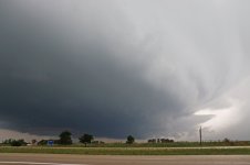
August 9, 2021: Looking north at a quite visible "minisupercell" updraft base with clear slot forming the "horseshoe" and a nub lowering/developing funnel on the north end, this was a few minutes before it produced an EF1 tornado near Kirkland, IL.
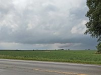
April 12, 2022: Looking northwest into a very murky, low-contrast storm, I can just make out a lighter area (clear slot) with a possible tornado (if you really squint) extending to the ground beneath the spot where the north end curls back into the storm. This is looking from Humboldt, IA toward Rutland, IA at the time an EF2 tornado was occurring just northwest of there, after I had missed the storm's previous, much more visible and photogenic tornado that tracked from near Palmer to near Gilmore City.
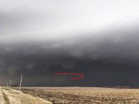
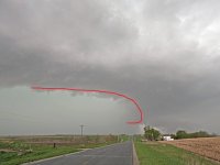
April 26, 2024: Looking west at a high-precipitation supercell rear flank near Shambaugh, IA, we can still visualize the "horseshoe" and use it to estimate roughly where the tornado (if present) should be. I noped on out of there, briefly being enveloped by precip on the leading edge of the RFD gust front due to bad road options. One important thing I've learned from Skip's videos is never try to race a tornado or potentially tornadic region of a storm across a point on its path (for example, starting out in the notch and trying to get south of the storm). It's like racing a train to a railroad crossing - if you tie, you lose.
However, I've since noticed that NOAA also uses it in their field guide. I don't know if their usage of the term pre-dates Skip's or if they got it from him.
Either way, it's certainly an apt description of the appearance and can help you get your bearings on the storm structure. I've taken a few of my own images and outlined where the "horseshoe" is or may be.
March 15, 2016; Hanna City, IL. Looking west-northwest, despite darkness having set in with just a bit of twilight remaining on the western horizon, lightning illuminates classic supercell structure with a very prominent "horseshoe" base and large cone funnel dangling below the north end right where we'd expect it. Although ground contact is obscured by the tree line, this is in fact an ongoing EF2 tornado.

July 14, 2021; Waverly, IA. Looking west-southwest, from within the "notch," with the forward-flank precip core just off to my right (north). The "horseshoe" is difficult to discern from this angle and I may not have marked it out entirely correctly, but we can identify a slight lightening of the clouds (clear slot) behind the area I have demarcated, with a nub lowering where the north end of it curls back into the storm, between the trees. This was roughly the area where a multiple-vortex EF2 tornado with a 12.7 mile path began approximately two minutes after the photo.

August 9, 2021: Looking north at a quite visible "minisupercell" updraft base with clear slot forming the "horseshoe" and a nub lowering/developing funnel on the north end, this was a few minutes before it produced an EF1 tornado near Kirkland, IL.

April 12, 2022: Looking northwest into a very murky, low-contrast storm, I can just make out a lighter area (clear slot) with a possible tornado (if you really squint) extending to the ground beneath the spot where the north end curls back into the storm. This is looking from Humboldt, IA toward Rutland, IA at the time an EF2 tornado was occurring just northwest of there, after I had missed the storm's previous, much more visible and photogenic tornado that tracked from near Palmer to near Gilmore City.

April 26, 2024: Looking west at a high-precipitation supercell rear flank near Shambaugh, IA, we can still visualize the "horseshoe" and use it to estimate roughly where the tornado (if present) should be. I noped on out of there, briefly being enveloped by precip on the leading edge of the RFD gust front due to bad road options. One important thing I've learned from Skip's videos is never try to race a tornado or potentially tornadic region of a storm across a point on its path (for example, starting out in the notch and trying to get south of the storm). It's like racing a train to a railroad crossing - if you tie, you lose.

Last edited:
